Rain Returns to North Texas
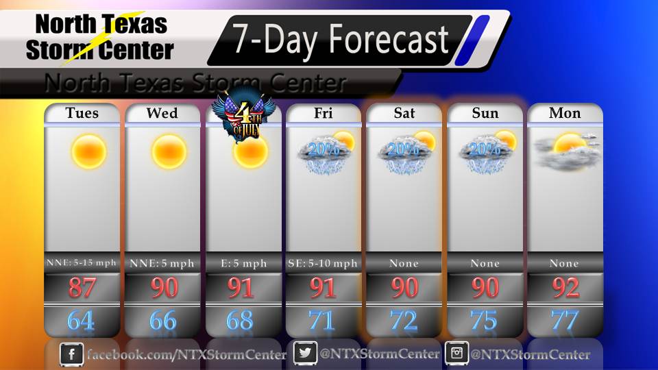
As we all know, tomorrow is Independence Day, the day that our great nation of the United States declared independence from Great Britain on July 4, 1776. To celebrate this holiday, many will be spending time with their families, going to parades, having barbecues, going to carnivals, having picnics, going to concerts and baseball games and MUCH more across North Texas tomorrow, but what will the weather be like for tomorrow's celebrations? Tomorrow, we expect a nice high of around 91 and mostly sunny skies across North Texas and winds South South East at about 5 miles per hour. Click here for a list of Fourth of July Events across North Texas.
0 Comments
This next week is looking like it will be a pleasant week across North Texas. We will be seeing some unseasonably low temperatures in the upper 80's and low 90's across North Texas this week. We will also be seeing our low temperatures overnight dipping down into the mid 60's and low 70's. Below is a more detailed graphic 7-Day Forecast:
A pleasant week is ahead for North Texas; for the first time this year, we expect to hit 90 degrees at DFW during this week, we expect to see some mild temperatures as we wake up this week, we could see some rain chances later this week and even during the beginning of next week. Below is your 7-Day Forecast: 7-Day Forecast for 5-14-13 through 5-20-13 Monday Night - Partly cloudy, with a low around 61. South wind 10 to 15 mph. Tuesday - Mostly sunny, with a high near 85. South southwest wind 10 to 15 mph, gusts as high as 20 mph. Tuesday Night - A 40% chance of showers and thunderstorms, mainly after 1 am. Mostly cloudy, with a low around 66. South wind around 15 mph, with gusts as high as 25 mph. Wednesday - A 50% chance of showers and thunderstorms. Mostly cloudy with a high near 80. South wind 15 to 20 mph, gusts as high as 25 mph. A FEW storms may be on the strong side, possibly even severe, however, widespread severe weather is not expected across North Texas on Wednesday as of now. Wednesday Night - A 30% chance of showers and thunderstorms. Mostly cloudy, with a low around 66. South southeast winds around 15 mph, gusts as high as 25 mph. Thursday - Partly sunny, with a high near 83. Winds south southeast at 10 to 15 mph, gusts as high as 20 mph. Thursday Night - Mostly cloudy, with a low around 67. Winds south southeast at 10 to 15 mph, gusts as high as 20 mph. Friday - Partly sunny, with a high near 86. South wind 10 to 15 mph, gusts as high as 20 mph. Friday Night - Partly cloudy, with a low around 68. South wind around 15 mph, gusts as high as 20 mph. Saturday - Partly sunny, with a high near 88. Saturday Night - Partly cloudy with a high around 68. Sunday - A 20% chance of showers and thunderstorms. Partly sunny with a high near 87. Sunday Night - A 20% chance of showers and thunderstorms. Mostly cloudy, with a low around 69. Monday - Mostly sunny, with a high near 87. Photo Courtesy of C Jill Reed (Flickr) The skies have once again opened up over North Texas for this weekend. A cold front moved in Friday afternoon and caused the skies to open up and give us some very nice and appreciated rains, as well as a nice cool down. Due to the cold front we will be seeing a very nice cool down this weekend with highs only in the mid 70's on Saturday and lower 80's on Sunday. as much as 1" to 3" of rain is expected to fall today. Remember to watch out in the low lying areas, as flooding could be likely today. The rain should move out of North Texas by Sunday morning. Be sure to keep with the latest from us on our Facebook Page, and our Twiter as well as on our Instagram! Here is the Categorical Outlook for North Texas today. Click to enlarge. Green = Slight Risk Orange = General T-Storm Risk Yellow = Moderate Risk Inside the yellow lines and along the Red River, there is a MODERATE risk, with a 60% chance of seeing a tornado. Tornado threats may be maximized along the Red River throughout the day. In North Texas, inside the green lines, we are in a SLIGHT risk of severe weather zone. Our tornadoes risk is much smaller here in North Texas, but an ISOLATED tornado CANNOT be ruled out however. Please remain vigilant as conditions may rapidly change throughout the day. Inside of the brown lines, there is a risk of GENERAL thunderstorms. |
Categories
All
|