Rain Returns to North Texas
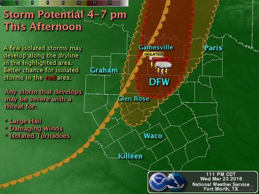
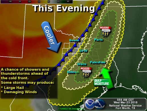
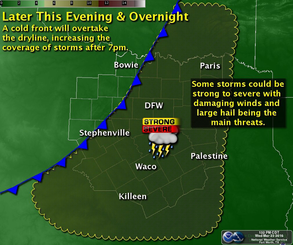
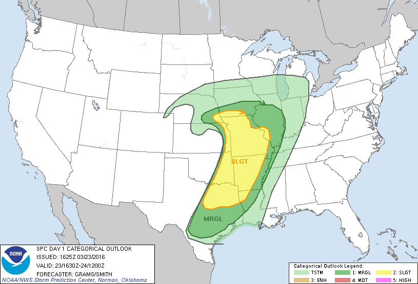
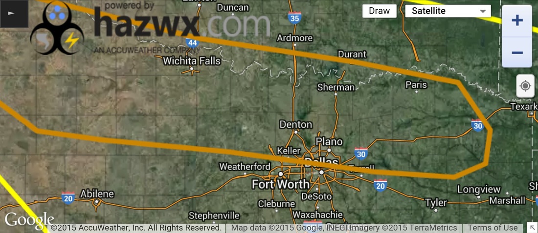
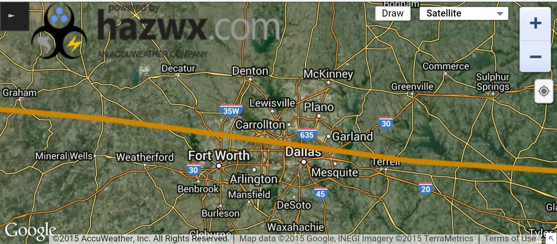
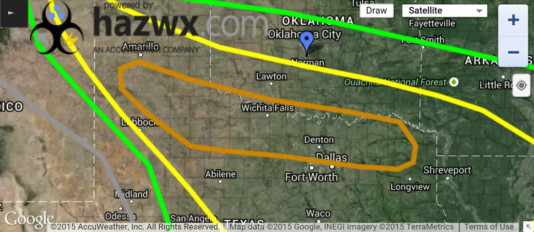
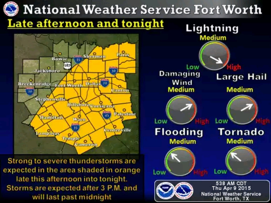
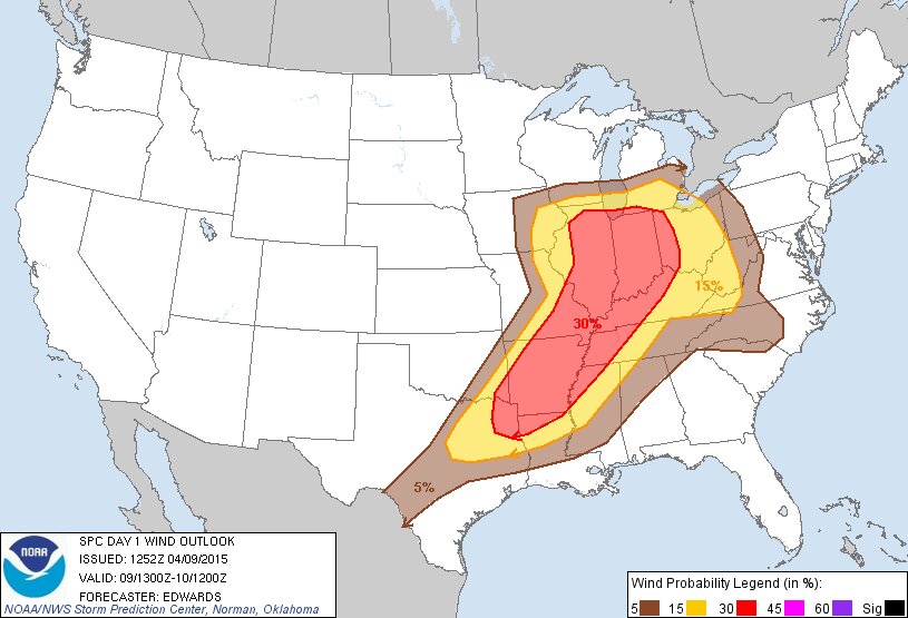
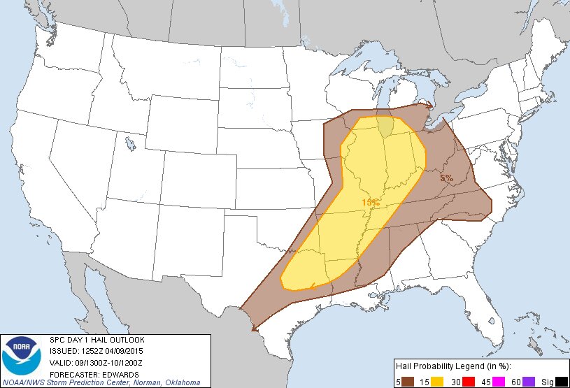
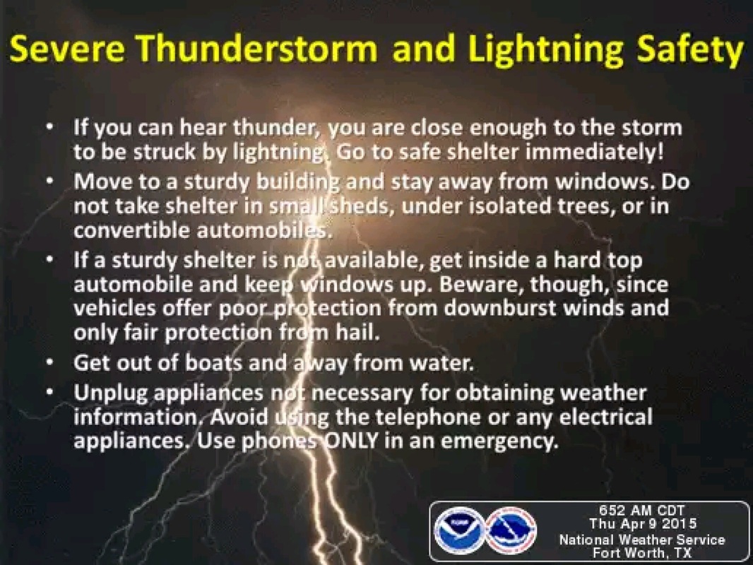
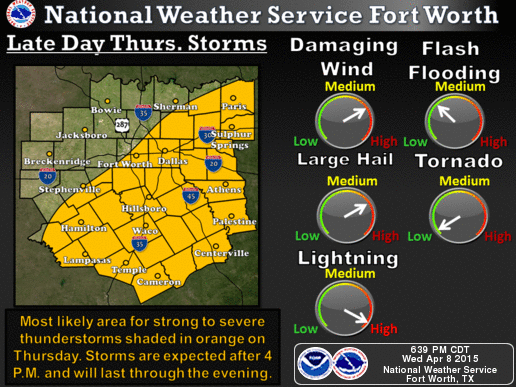
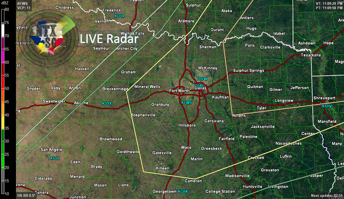
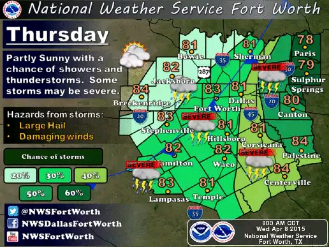
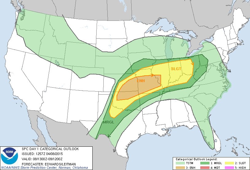
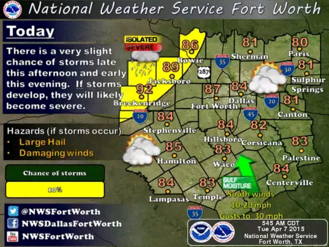
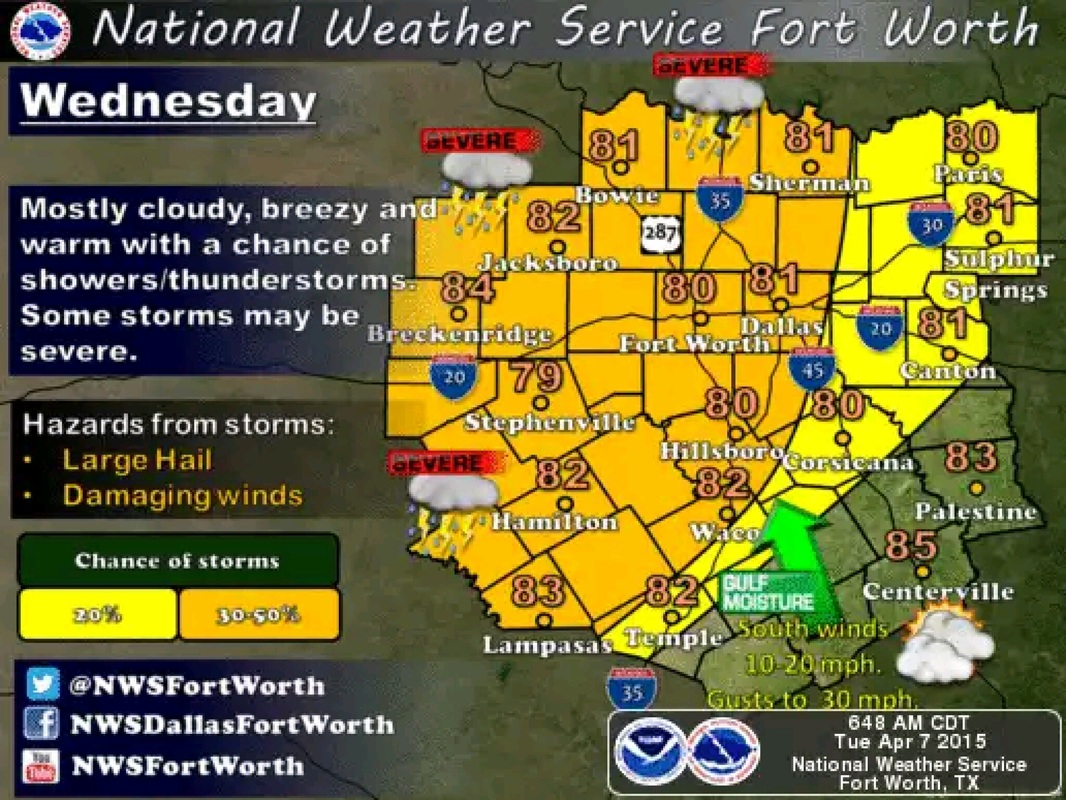
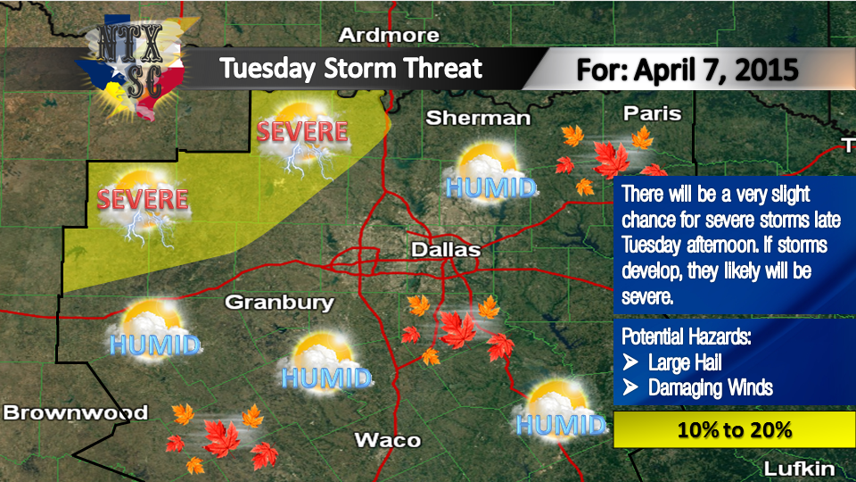
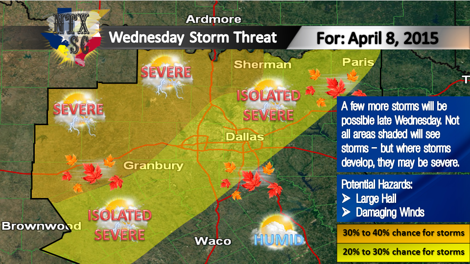
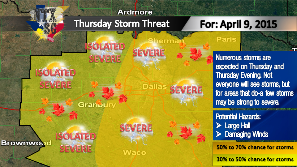
Severe Thunderstorm Watch for Bosque, Collin, Comanche, Cooke, Dallas, Delta, Denton, Ellis, Erath, Fannin, Grayson, Hamilton, Hill, Hood, Hopkins, Hunt, Johnson, Kaufman, Lamar, Mills, Montague, Parker, Rains, Rockwall, Somervell, Tarrant, Wise [TX] till Mar 24, 12:00 AM CDT
0 Comments
NWS Storm Prediction Center Outlook - 03/23/16 - 2:46 PMImages above courtesy: NWS SPC Norman, OK Courtesy NWS Storm Prediction Center Norman, OK: DAY 1 CONVECTIVE OUTLOOK NWS STORM PREDICTION CENTER NORMAN OK 0245 PM CDT WED MAR 23 2016 VALID 232000Z - 241200Z ...THERE IS A SLGT RISK OF SVR TSTMS ACROSS PARTS OF THE CNTRL PLAINS...LOWER TO MID MO VALLEY...OZARKS...ARKLATEX AND SRN PLAINS... ...THERE IS A MRGL RISK OF SVR TSTMS ACROSS PARTS OF THE CNTRL PLAINS...MID MO VALLEY...MID MS VALLEY...ARKLATEX AND SRN PLAINS OUTSIDE OF THE SLIGHT RISK AREA... ...SUMMARY... ISOLATED TO SCATTERED SEVERE STORMS SHOULD DEVELOP LATE THIS AFTERNOON ACROSS PARTS OF THE LOWER MISSOURI VALLEY AND THIS EVENING FROM THE OZARKS INTO NORTH-CENTRAL TEXAS. LARGE HAIL...A FEW TORNADOES...AND DAMAGING WINDS WILL BE POSSIBLE. STRONG TO ISOLATED SEVERE STORMS MAY PERSIST INTO THE OVERNIGHT FROM THE MID-MISSISSIPPI VALLEY INTO EAST TEXAS. SEVERAL CHANGES HAVE BEEN MADE TO THE OUTLOOK FOR THIS ISSUANCE. THE FIRST CHANGE IS TO EXTEND THE SLIGHT RISK AREA A BIT WWD ACROSS ERN KS...ECNTRL OK AND NCNTRL TX TO ACCOUNT FOR CELL INITIATION SLIGHTLY FURTHER WEST. HAVE ALIGNED THE WRN MARGINAL RISK LINE UP CLOSELY TO WHERE THE HRRR FIRST INITIATES STORMS LATE THIS AFTERNOON. THE SECOND CHANGE TO THE OUTLOOK IS TO REMOVE THE SLIGHT RISK AREA FROM PARTS OF SW IL...ERN MO...ERN/SRN AR...AND NW LA. CONVECTION IS NOT FORECAST TO DEVELOP IN THIS CORRIDOR UNTIL AFTER 06Z AND INSTABILITY IS FORECAST TO REMAIN WEAK. FOR THIS REASON...THE SEVERE THREAT IS EXPECTED TO REMAIN MARGINAL ALONG THIS CORRIDOR TONIGHT. THE LAST CHANGE TO THE OUTLOOK IS TO REORIENT A CORRIDOR OF THUNDER TO INCLUDE MUCH OF SW AND CNTRL NEB WHERE THUNDERSTORMS ARE ONGOING. THIS ACTIVITY SHOULD CONTINUE THROUGH LATE AFTERNOON AND MAY EXPAND A BIT NWWD INTO PARTS OF NRN AND WCNTRL NEB LATE THIS AFTERNOON. . .BROYLES.. 03/23/2016 NWS Fort Worth Short Term Forecast - 03/23/16 - 3:06 PM.NOW... ISOLATED STORMS ARE POSSIBLE ALONG THE DRYLINE BETWEEN 4 AND 8 PM FOR AREAS MAINLY WEST OF INTERSTATE 35. IF STORMS DEVELOP...THE MAIN THREATS WILL BE DAMAGING WINDS AND LARGE HAIL. CANNOT RULE OUT THE POSSIBILITY OF A TORNADO. CRITICAL FIRE WEATHER CONDITIONS CONTINUE FOR LOCATIONS WEST OF A GAINESVILLE TO LAMPASAS LINE. THERE WILL BE AN INCREASE IN STORM COVERAGE AS THE COLD FRONT APPROACHES FROM THE NORTH THIS EVENING INTO THE OVERNIGHT HOURS. MAIN THREATS FOR THE STORMS ALONG THE COLD FRONT WILL BE DAMAGING WINDS AND LARGE HAIL.
$$ HERNANDEZ Courtesy NWS Fort Worth, TX: A dryline is expected to mix eastward towards the I-35 corridor late this afternoon. A cap, layer of warm air aloft, is expected to suppress most afternoon convection; however, an isolated storm or two will be possible mainly east of I-35. If storms develop, they may become strong to severe , with large hail and damaging winds being the primary threats. A tornado or two cannot be ruled out. In addition, a Critical Fire Weather Threat is expected to develop behind the dryline along and west of the Highway 281 corridor. A cold front will overtake the dryline this evening, leading to an increase in thunderstorm coverage after about 7pm this evening. Some storms along the cold front could be strong to severe, with damaging winds and hail being the primary threats. Courtesy NWS Fort Worth, TX: Coverage of storms should increase after 7pm & persist overnight. Some strong/severe storms possible. The National Weather Service Storm Prediction Center in Norman, Oklahoma has issued a SLIGHT risk for severe thunderstorms across North Texas, including the DFW Metroplex, this afternoon and evening. Stay tuned this afternoon and evening for further information and updates, and watches and warnings if they are issued.
The NWS Storm Prediction Center has now expanded the "Enhanced" Outlook zone to include the DFW Metroplex. The outflow boundary from the storms along the Red River earlier this morning has now reached the DFW Metroplex, this will be the main focus for severe PM storms. Severe weather is expected across parts of the region Wednesday through Friday. A few tornadoes are possible late Wednesday afternoon into Wednesday evening. With that in mind, here are a few tornado safety tips. If you have an underground shelter go there; otherwise, move to an interior room or hallway on the lowest floor. Get under a sturdy piece of furniture.
Good morning everyone, wanted to give a quick update on what to expect from today's storms. As of this morning, the "enhanced" risk region no longer covers most of North Texas, and instead just covers the Red River counties down in to Dallas and Tarrant, but only a small sliver in the extreme North of those cointies, leaving the rest of North Texas under a "Slight" risk. However, this does not mean we can let our guard down for counties outside of the "Enhanced" risk areas, folks inside of the "Slight" risk area need to pay close attention as well. The brownish orange colored outline represents the "Enhanced" risk area, the yellow colored outline represents the "Slight" risk area. Threats today may include: • Large Hail
• Frequent Lightning Forecast Timing for today's storms is between 4 PM and 12 AM.
Good morning everyone! Just wanted to give a quick update on today's storm event. It's looking like this could be a busy afternoon and evening across North Texas weather-wise. Images courtesy NWS Fort Worth, TX. Courtesy: NWS Fort Worth - The highest risk will be for lightning with large hail and damaging winds being the next highest. There is a risk for flash flooding. There is a low, but none zero, tornado risk. The best chance for strong to severe storms will be late this afternoon into this evening but chances will continue into the overnight hours. The most likely area for storms to develop will be along and southeast of a Goldthwaite to DFW to Sherman line. There is a SLIGHT risk for severe storms across North Texas this afternoon, as represented on the map as the areas in Yellow. Here are some thunderstorm safety tips. If you can hear thunder, you are close enough to be struck by lightning. Go to a safe shelter immediately! Move to a sturdy building and stay away from windows. Get out of boats and away from water.
All is calm right now across North Texas for this Wednesday night, however, that may not be the case for us here in North Texas Thursday evening. A cold front is expected to move into North Texas tomorrow (Thursday), and we expect storms to begin to fire up and develop along this front by late afternoon Thursday. If storms are able to develop, there will be a good chance that they will become strong, if not severe. The highest risk will be for lightning with large hail and damaging winds being the next highest. There is a risk for flash flooding with a relatively LOW tornado risk. The best chance for strong to severe storms will be late in the day on Thursday. Portions of North Texas will be in the "Enhanced" risk level tomorrow afternoon as of this evening, however this is NOT set in stone and this COULD change. The "Enhanced" risk area looks to only contain areas in NE Texas at this time, as represented by the area circled in "peach" color. Areas under this "Enhanced" risk as of tomorrow afternoon could possibly see the threat of larger hail and a few tornadoes. Areas in North Texas not included in this "Enhanced" risk will be under a "Slight" risk, as represented by the area circled in Yellow. Again, this is NOT set in stone, and COULD change as well. Areas under this "Slight" risk as of tomorrow afternoon could possibly see the threat of large hail and isolated tornadoes CANNOT be ruled out. There are still many uncertainties at this time for this event. Timing, threats, risks, risk levels, risk areas, outlooks etc. COULD change as we go through tonight and through the morning and day time hours tomorrow and continue to receive new data. Please stay tuned for updates tomorrow and tomorrow morning, and remember to BE WEATHER AWARE TOMORROW (THURSDAY) AFTERNOON AND EVENING.
Good morning everyone! Here's a quick update on the possible severe storms this week. Images and forecasts are courtesy of the NWS Fort Worth. This Afternoon (Wednesday) Courtesy NWS Fort Worth - It will be partly sunny, warm and breezy through this evening as south winds of 10 to 20 mph continue. Some gusts around 30 mph are possible. There will be a chance of showers and thunderstorms along and northwest of a Cameron to Palestine line. Some storms may be severe late this afternoon into tonight along and northwest of a Goldthwaite to Dallas to Paris line. Large hail and damaging downburst winds will be the primary hazards. Thursday
Courtesy NWS Fort Worth - Chances of showers and thunderstorms will continue on Thursday as an upper level trough translates the Central and Southern Plain, and a cold front pushes through the region. The best chances for storms will be across the eastern half of the region. Some storms should become severe with large hail and damaging winds. Good morning everyone! Here's a quick update on the possible severe storms this week. Images and forecasts are courtesy of the NWS Fort Worth. Today (Tuesday) Courtesy NWS Fort Worth - Some isolated thunderstorms are possible late this afternoon and early this evening along and northwest of a Cisco to Bowie line. IF storms develop, they will likely become severe with large hail and damaging winds being the primary hazards. Cloud-to-ground lightning and heavy rain may also accompany these storms. Otherwise, expect warm, breezy and humid conditions today. Temperatures will climb into the 80s at most locations and a few spot across the northwest will reach the lower 90s. Wednesday Courtesy NWS Fort Worth - There will be a chance of showers and thunderstorms across much of North and Central Texas Wednesday with the best chances being along and west of I-35. Some strong to severe storms are possible. The main hazards with these storms will be from large hail, damaging straight-line winds and lightning. A heavy rain threat will also be possible beneath any slow-moving thunderstorms. Thursday
Courtesy NWS Fort Worth - Chances of showers and thunderstorms will continue on Thursday as an upper level trough translates the Central and Southern Plain, and a weak cold front pushes through the region. The best chances for precipitation will likely occur across the eastern half of the region. A few storms should become severe with large hail and damaging winds. Storms should end from west to east Thursday evening. I hope everyone has enjoyed this Easter weekend and the cooler weather! This next week, we will climb back up into the 80s each day through Thursday, and also have some chances of rain in the forecast each day. Monday and Tuesday, we only have about a 20% chance of rain at the highest amounts. Of course, anything that may form could become strong to severe, small to large hail and damaging winds would be the main threats, however, we don't expect much to happen Monday or Tuesday. On Tuesday, if we see any storms, they will mainly be in Northwestern portions of the region where the atmosphere will be more favorable. Wednesday and Thursday however, we expect a higher chance of storms for the region, these may be strong to severe. Wednesday, we will heat up into the low to mid 80s, we will be windy across much of the area, with about a 30% to 40% chance of storms to the West and Northwest of the DFW Metroplex, and a 20% to 30% isolated chance of storms including the Metroplex and an area roughly from Sherman to Paris and Southward to Brownwood. The main threats for Wednesday will be small to large hail and damaging winds.
On Thursday, we will see the greatest chance of storms for this week. Numerous storms will be expected across the region. This greatest threat WILL include the DFW Metroplex, with a 50% to 70% chance of storms. Any storms that develop in the orange shaded area of the map for Thursday will likely be severe. The main threats for Thursday will be small to large hail and damaging winds. It's still a few days out for Wednesday and Thursday, so the forecasts and predictions may change. As I say that at this time, I wouldn't rule out the isolated possibility for a tornado or two Wednesday or Thursday (mainly for Thursday) in the areas with the greater storm chances, given the fact that severe thunderstorms sometimes may organize themselves into tornadic supercells...however, that may change over the coming days, and I am NOT saying this will be a severe weather or tornado outbreak AT THIS TIME. I also do not expect tornadoes to be a main threat AT THIS TIME, and again this COULD change. We do encourage you again, to pay attention to the latest forecasts and latest information this week as forecasts could potentially change and risk levels and threats may change as we near the event and begin to analyze new information and data. We will have more updates for the storm threats and forecasts tomorrow evening...please stay tuned! |
Categories
All
|