• Large Hail
- Damaging Winds
- A Few Tornadoes
• Frequent Lightning
|
Good morning everyone, wanted to give a quick update on what to expect from today's storms. As of this morning, the "enhanced" risk region no longer covers most of North Texas, and instead just covers the Red River counties down in to Dallas and Tarrant, but only a small sliver in the extreme North of those cointies, leaving the rest of North Texas under a "Slight" risk. However, this does not mean we can let our guard down for counties outside of the "Enhanced" risk areas, folks inside of the "Slight" risk area need to pay close attention as well. The brownish orange colored outline represents the "Enhanced" risk area, the yellow colored outline represents the "Slight" risk area. Threats today may include: • Large Hail
• Frequent Lightning Forecast Timing for today's storms is between 4 PM and 12 AM.
0 Comments
Good morning everyone! Here's a quick update on the possible severe storms this week. Images and forecasts are courtesy of the NWS Fort Worth. Today (Tuesday) Courtesy NWS Fort Worth - Some isolated thunderstorms are possible late this afternoon and early this evening along and northwest of a Cisco to Bowie line. IF storms develop, they will likely become severe with large hail and damaging winds being the primary hazards. Cloud-to-ground lightning and heavy rain may also accompany these storms. Otherwise, expect warm, breezy and humid conditions today. Temperatures will climb into the 80s at most locations and a few spot across the northwest will reach the lower 90s. Wednesday Courtesy NWS Fort Worth - There will be a chance of showers and thunderstorms across much of North and Central Texas Wednesday with the best chances being along and west of I-35. Some strong to severe storms are possible. The main hazards with these storms will be from large hail, damaging straight-line winds and lightning. A heavy rain threat will also be possible beneath any slow-moving thunderstorms. Thursday
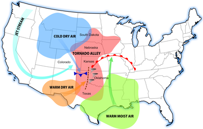
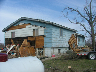
Courtesy NWS Fort Worth - Chances of showers and thunderstorms will continue on Thursday as an upper level trough translates the Central and Southern Plain, and a weak cold front pushes through the region. The best chances for precipitation will likely occur across the eastern half of the region. A few storms should become severe with large hail and damaging winds. Storms should end from west to east Thursday evening.  A diagram of tornado alley's rough location (red) Well, it's that time of year, Spring! While it is an absolutely amazing time to watch all of the new plant life bloom, it is also is a time when we have to watch the skies as well. As many of us North Texans know, North Texas can be a very dangerous place come spring time.. mainly because we're in a region know as 'Tornado Alley'. In case you might not know what Tornado Alley is, Tornado Alley is the region in the United States where most of the tornadoes reported annually occur. North Texas just happens to lie right inside of 'Tornado Alley'. Tornado Alley includes the states of Texas, Kansas, Oklahoma, Nebraska, Iowa, Illinois & Missouri. The main reason that 90% of tornadoes hit this region of the U.S because cold, dry air from Canada and the Rocky Mountains meets warm, moist air from the Gulf of Mexico and hot, dry air from the Sonoran Desert, which causes atmospheric instability, heavy precipitation, and many intense thunderstorms. Since I live in Tornado Alley, what preparedness actions should I take? Stock photo of extensive tornado damage to a home. Well, the first thing to note is that tornadoes don't jest happen in the Spring. Tornadoes can occur any time of day, any day of the year so you need to make sure that you are prepared and stay prepared year round and be ready to act at a moments notice. The first preparedness action you should take for a tornado is that you have a safe place to go should a tornado occur. The safest place to be is an an underground shelter, basement or a safe room, however, if there is no safe room, underground shelter or basement available then you should go to a small, windowless interior room or hallway on the lowest level of a sturdy building. "What if I live in a mobile home?" Well here's the thing about mobile homes, they are not safe at all from tornadoes. They can easily be picked up and thrown around like a toddler throwing his toy cars about. If you are in a mobile home during a tornado, abandon it and go to the nearest sturdy building or shelter immediately. "But, what if I'm caught outside during a tornado?" If you are caught outside in the event of a tornado, try to find a sturdy building, storm shelter or basement to seek shelter in. If you cannot quickly walk to a shelter, immediately get into a vehicle, buckle your seatbelt and try to drive to the closest sturdy shelter. If flying debris occurs while you are driving, pull over and park. You have the following options as a last resort; a. stay in your vehicle with the seatbelt on. Put your head down below the windows, covering your hands with a blanket if possible. or b. if you can safely get noticeably lower than the level of the roadway, exit your car, and lie in that area, covering your head with your hands.. your choice should be driven by your specific circumstances. Just remember, to always have a plan in place as severe weather and tornadoes can strike ANY TIME, ANY DAY OF THE YEAR. Severe Weather Preparedness Guides Below I have attached links to some severe weather safety guides from The Red Cross and The National Weather Service. Click 'read more' to view the guide links.
|
Categories
All
|