Storms Developing Soon
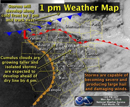
Storms are expected to develop across the North Texas region during the next couple of hours. Between now and 3 pm, most of the storms will form along a cold front that is moving southeast into the area. Other isolated storms are expected to develop ahead of a dry line where the cumulus clouds are growing taller into showers and eventually storms. All thunderstorms will have the potential to become severe and produce large hail and damaging winds today. An isolated tornado will be possible, especially near the warm front location.
Severe Potential Today
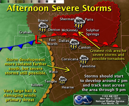
11 AM UPDATE: The surface low is tracking farther south than expected, which should pull the risk of severe storms a little farther to the southwest than our previous forecast. Since the atmosphere is very unstable today, any storms that develop will have the potential to produce large hail and damaging winds. The region where severe storms are most likely today is expected to be near and just to the north of the warm front (the area north of a Denton to Plano to Canton line) where isolated tornadoes will also be possible. Storm coverage will be lower farther south into Central Texas. Storms are expected to start to develop around 2 to 4 pm and they will track east across the region thro
Severe Thunderstorm Watch until 9 PM

SEL5 URGENT - IMMEDIATE BROADCAST REQUESTED SEVERE THUNDERSTORM WATCH NUMBER 85 NWS STORM PREDICTION CENTER NORMAN OK 135 PM CDT MON APR 11 2016 THE NWS STORM PREDICTION CENTER HAS ISSUED A * SEVERE THUNDERSTORM WATCH FOR PORTIONS OF PARTS OF SOUTHWESTERN ARKANSAS SOUTHERN OKLAHOMA PORTIONS OF NORTHERN AND EASTERN TEXAS * EFFECTIVE THIS MONDAY AFTERNOON AND EVENING FROM 135 PM UNTIL 900 PM CDT. * PRIMARY THREATS INCLUDE... SCATTERED LARGE HAIL AND ISOLATED VERY LARGE HAIL EVENTS TO 3 INCHES IN DIAMETER POSSIBLE ISOLATED DAMAGING WIND GUSTS TO 70 MPH POSSIBLE A TORNADO OR TWO POSSIBLE SUMMARY...THUNDERSTORMS HAVE BEGUN DEVELOPING NEAR AND JUST NORTH OF THE RED RIVER EARLY THIS AFTERNOON...WITH CONTINUED DEVELOPMENT NEAR AND SOUTH OF THE RIVER INTO NORTHERN -- AND EVENTUALLY EASTERN -- TEXAS EXPECTED OVER THE NEXT FEW HOURS. VERY LARGE HAIL CAN BE EXPECTED WITH THE STRONGEST STORMS...ALONG WITH LOCALLY DAMAGING WINDS AND POSSIBLY A TORNADO OR TWO. THE SEVERE THUNDERSTORM WATCH AREA IS APPROXIMATELY ALONG AND 90 STATUTE MILES NORTH AND SOUTH OF A LINE FROM 55 MILES NORTHWEST OF FORT WORTH TEXAS TO 55 MILES SOUTH OF DE QUEEN ARKANSAS. FOR A COMPLETE DEPICTION OF THE WATCH SEE THE ASSOCIATED WATCH OUTLINE UPDATE (WOUS64 KWNS WOU5). PRECAUTIONARY/PREPAREDNESS ACTIONS... REMEMBER...A SEVERE THUNDERSTORM WATCH MEANS CONDITIONS ARE FAVORABLE FOR SEVERE THUNDERSTORMS IN AND CLOSE TO THE WATCH AREA. PERSONS IN THESE AREAS SHOULD BE ON THE LOOKOUT FOR THREATENING WEATHER CONDITIONS AND LISTEN FOR LATER STATEMENTS AND POSSIBLE WARNINGS. SEVERE THUNDERSTORMS CAN AND OCCASIONALLY DO PRODUCE TORNADOES. && OTHER WATCH INFORMATION...CONTINUE...WW 84... AVIATION...A FEW SEVERE THUNDERSTORMS WITH HAIL SURFACE AND ALOFT TO 3 INCHES. EXTREME TURBULENCE AND SURFACE WIND GUSTS TO 60 KNOTS. A FEW CUMULONIMBI WITH MAXIMUM TOPS TO 550. MEAN STORM MOTION VECTOR 26035. ...GOSS
Ready for Severe Weather?
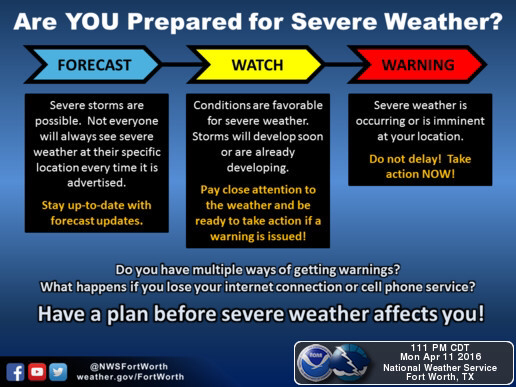
Are you prepared for severe weather? Here's a graphic that shows how YOU can become weather ready for severe storms expected this afternoon and evening! Don't be scared, just prepared!